

Trolley Route

Red Bus Route
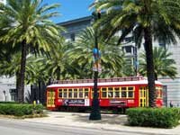
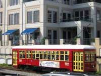
New Orleans Streetcars are a great way to get out and explore New Orleans. The historic New Orleans streetcars travel throughout the Crescent City on four different lines: the St Charles Streetcar route, the Canal St Streetcar route and the Riverfront Streetcar route and the Loyola Avenue/Union Terminal loop. So climb aboard and take a trip into the past on a New Orleans streetcar. The (red) streetcars running along Canal Street, the Riverfront and the Loyola loop are more modern than those (green) running along the St. Charles Avenue route and they have more conveniences. These streetcars are fully air-conditioned with wider doors that allow for handicap access. The street cars only accept cash or passes. For information on purchasing passes go to the New Orleans RTA website. To avoid paying each time you board I recommend you purchase a one day Jazzy Pass.
New Orleans Streetcar FAQs
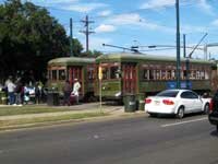
The famous St. Charles Line is the oldest continuously operating streetcar in the world! The route is a 13 mile long loop and runs from Canal Street to Carondelet Avenue. Traveling down St Charles Avenue you will get to see dozens of historic New Orleans mansions. For extra fun you should get off along the way and enjoy a meal at one of the restaurants along the route. For more information on restaurants and attractions along the St. Charles Streetcar route visit my St Charles Streetcar page.
The Canal Street Streetcar has two routes; the Canal Streetcar Cemeteries and the Canal Streetcar City Park/Museum. Both Canal Street routes take you down the center of Canal Street from the river at the foot of Canal St to South Carrollton Avenue. It is at S. Carrollton that each route heads to if final destination. The Canal Streetcar Cemeteries route is a 7 mile long route that starts at the foot of Canal St and ends at the historic New Orleans cemeteries on City Park Avenue. The Canal Streetcar City Park/Museum route is a 7.5 mile long route that starts at the foot of Canal St and end near the New Orleans Museum of Art in City Park.
The Riverfront Line does exactly as it says in takes you along the New Orleans Riverfront. Stops along the Riverfront streetcar line include the Riverwalk Market Place(shopping and eating) * Canal Street ferry terminal(cross the Mississippi River) * Aquarium of the Americas(lots of neat fish n things)* IMAX theatre(great movie) * Waldenburg Park(picnics, relaxing, and river view) * Moonwalk and Caf� Du Monde(coffee and beignets) * New Orleans French Market(shopping and flee market) * The Shops at Canal Place(more shopping and eating) * Cruise Ship Terminal * The Ernest N. Morial Convention Center

The newest addition to the New Orleans streetcar lines is the Loyola Avenue/Union Passenger Terminal streetcar route. This streetcar line is about a mile and half long and includes stops near the Hyatt Regency Hotel/Superdome and the Union Passenger Terminal. For visitors arriving in the Big Easy by Greyhound bus or Amtrak trains, the Loyola streetcar will provide transportation from the terminal to Canal Street and the French Quarter. The existing fleet of the red Canal Street and Riverfront streetcars will accommodate the Loyola loop. These streetcars are fully air-conditioned with wider doors that allow for handicap access.